
Research answer
What AppTrendKit can say about Mapit GIS today
Mapit GIS has no estimate-backed download or gross-consumer-spend figure that meets the public evidence contract yet.
Observed App Store metadata, chart positions, and history are shown below. Missing, non-finite, undefined-currency, or undefined-metric evidence stays missing rather than becoming zero.
Performance intelligence
Observed trajectory and estimates
Store ranks are observations. Downloads and gross store consumer spend are AppTrendKit estimates and only appear when persisted evidence exists.
Estimated downloads · 30D
ModeledNo persisted estimate
The page does not turn missing evidence into zero.
Estimated App Store gross consumer spend · 30D
ModeledNo persisted estimate
The page does not turn missing evidence into zero.
Estimated downloads · 7D
ModeledNo persisted estimate
The page does not turn missing evidence into zero.
Estimated App Store gross consumer spend · 7D
ModeledNo persisted estimate
The page does not turn missing evidence into zero.
Evidence history
Collected daily performance
No daily metric history has been persisted yet.
Rank history
Observed chart positions
Lower rank is better. Only collected observations are shown.
Coverage note
What the ranks mean
A missing rank is not treated as zero downloads or zero revenue. Apple chart feeds are bounded and may return censored or not-ranked observations outside the visible chart depth.
Read the methodStorefront mix
Top countries by estimated contribution
Country estimates are aggregated only after country-level predictions exist.
Monetization
Observed store economics signals
These are listing and product observations. They are not company revenue, subscriber counts, or advertising revenue.
App details
Store metadata
- Version
- 1.9
- Released
- Feb 19, 2026
- Last updated
- Aug 8, 2026
- Content rating
- 4+
- Default storefront
- RO
Public IAP observations
Validated in-app purchase prices
Only persisted rows with an explicit public publication boundary are shown. Missing price, currency, country, or date values stay unknown.
Listing detail
What the store says
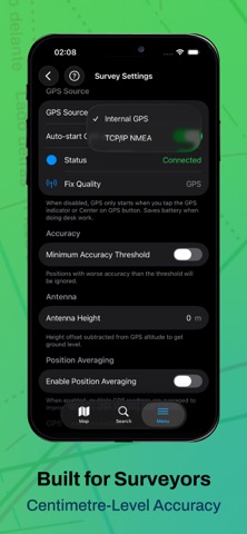
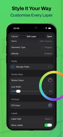
Trusted by GIS professionals for field data collection. Mapit GIS brings professional-grade spatial data capture to iPhone and iPad, designed for surveyors, environmental consultants, foresters, and anyone who works with spatial data in the field. Download for free and start mapping immediately. Optional paid subscriptions unlock additional features as described below. FREE FEATURES (included with download, no purchase required): - GeoPackage Native: Manage your data through GeoPackage projects (.gpkg) for seamless data sharing with desktop GIS applications like QGIS or ArcGIS. - Capture Points, Lines, and Polygons - Create vector features directly on the map using GPS or manual placement - Support for complex multi-part geometries. Free tier includes 1 project - 3 layers, and 20 features per layer. - Custom Attributes with Forms Design data collection forms with dropdowns, multi-select lists, dates, and barcode scanners. Customise your workflow for each project. - GeoJSON Export and Import Export and import data in GeoJSON format. - Professional Styling Customise feature colours, sizes, and labels. Apply styles based on the attribute values. PRO SUBSCRIPTION FEATURES (paid subscription): Available as an auto-renewable subscription (see price in your local currency): - Unlimited Projects, Layers, and Features Remove all limits on projects, layers, and features per layer. - Full Format Export and Import Export and import in Shapefile, KML, GPX, CSV, and DXF formats in addition to GeoJSON. - Offline Maps Add MBTiles offline basemaps for fieldwork in areas without connectivity. - Online Map Services Connect to WMS, WFS, WMTS, and XYZ tile services for custom basemaps and reference layers. - GPS Track Recording Automatically capture vertices while walking for line and polygon surveys. - External GNSS Receivers Connect to external GNSS receivers via TCP/IP or Bluetooth LE for high-precision positioning. View HDOP, VDOP, PDOP, fix type, and satellite constellation data. Compatible with RTK-corrected coordinate streams. Bluetooth Classic is currently supported for EOS Positioning (Arrow series) and Juniper Systems devices (Geode, Spire). - Position Averaging Improve point accuracy by averaging multiple GPS readings for survey-grade results. - Feature and Place Search Search within your GeoPackage data and find places on the map. PRO+ SUBSCRIPTION FEATURES (paid subscription): Pro+ includes all Pro features plus the following. Available as an auto-renewable subscription (see price in your local currency): - NTRIP RTK Corrections Connect to NTRIP casters to receive real-time RTK corrections for centimetre-accurate positioning. Browse and select mountpoints sorted by distance, monitor RTCM data streams, and send GGA position feedback. RTCM corrections are forwarded to your connected GNSS receiver via TCP or Bluetooth LE. Compatible with services such as rtk2go.com and commercial NTRIP providers. IDEAL FOR: - Environmental Surveys & Ecology - Forestry Planning & Woodland Management - Agriculture & Soil Surveys - Land Surveying & Site Surveys - Tree Surveys & Arboriculture - Construction & Infrastructure - Utilities & Asset Management SUBSCRIPTION INFORMATION: Mapit GIS Pro and Pro+ are available as monthly or annual auto-renewable subscriptions. Prices are displayed in your local currency on the subscription page. Pro subscribers can upgrade to Pro+ at any time with prorated pricing. Payment is charged to your Apple ID account at confirmation of purchase. Subscriptions automatically renew unless cancelled at least 24 hours before the end of the current period. You can manage and cancel subscriptions in your Apple ID account settings. Terms of Use: https://mapitgis.com/terms Privacy Policy: https://mapitgis.com/privacy-policy
Publisher websiteStore creative
Screenshots




Competitive set
Similar apps
Deterministic links to real stored apps matched by category, publisher, and comparable performance bands.

AdLock: Ad Blocker for Browser
Hankuper s.r.o.

AgroRK
Kristijan Hrek

Al-Jawdah LS
Rubik Smart Solutions

AQ
Quanta Computer Inc.

AVG Secure VPN & Proxy server
AVG eCommerce CY Limited

Awesome Screenshot for Safari
Diigo

AYOA - Mind Mapping
OpenGenius Limited

BLE Scanner 4.0 – Bluetooth LE
BLUEPIXEL TECHNOLOGIES LLP
Methodology and provenance
Read every number with its evidence
Metadata source: Apple iTunes Search API; observed Sep 7, 2026, 8:39 PM.
Rankings: collected chart positions from the listed storefront. Missing ranks are not zeros.
Economics: downloads and gross store consumer spend are estimated, not official Apple or publisher figures.
Model: No persisted model version.
Confidence: —; intervals widen when evidence or history is limited.
Last observation: Sep 7, 2026, 8:39 PM.
See how AppTrendKit separates observations, estimates, coverage, and confidence.
Open methodology