
Research answer
What AppTrendKit can say about EU Fires today
EU Fires has no estimate-backed download or gross-consumer-spend figure that meets the public evidence contract yet.
Observed App Store metadata, chart positions, and history are shown below. Missing, non-finite, undefined-currency, or undefined-metric evidence stays missing rather than becoming zero.
Performance intelligence
Observed trajectory and estimates
Store ranks are observations. Downloads and gross store consumer spend are AppTrendKit estimates and only appear when persisted evidence exists.
Estimated downloads · 30D
ModeledNo persisted estimate
The page does not turn missing evidence into zero.
Estimated App Store gross consumer spend · 30D
ModeledNo persisted estimate
The page does not turn missing evidence into zero.
Estimated downloads · 7D
ModeledNo persisted estimate
The page does not turn missing evidence into zero.
Estimated App Store gross consumer spend · 7D
ModeledNo persisted estimate
The page does not turn missing evidence into zero.
Evidence history
Collected daily performance
No daily metric history has been persisted yet.
Rank history
Observed chart positions
Lower rank is better. Only collected observations are shown.
Coverage note
What the ranks mean
A missing rank is not treated as zero downloads or zero revenue. Apple chart feeds are bounded and may return censored or not-ranked observations outside the visible chart depth.
Read the methodStorefront mix
Top countries by estimated contribution
Country estimates are aggregated only after country-level predictions exist.
Monetization
Observed store economics signals
These are listing and product observations. They are not company revenue, subscriber counts, or advertising revenue.
App details
Store metadata
- Version
- 3.7
- Released
- Feb 11, 2026
- Last updated
- Sep 3, 2026
- Content rating
- 4+
- Default storefront
- AT
Public IAP observations
Validated in-app purchase prices
Only persisted rows with an explicit public publication boundary are shown. Missing price, currency, country, or date values stay unknown.
Listing detail
What the store says
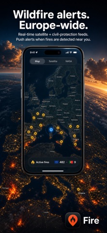
Fire — Real-Time Wildfire Monitoring Fire brings live wildfire monitoring to your fingertips using NASA satellite data, the Copernicus EFFIS European feed, and Portuguese Civil Protection sources. Stay informed about active fires across Europe, receive instant push alerts when a wildfire is detected near you, and contribute on-the-ground reports to help your community. REAL-TIME SATELLITE DATA Live fire detection from NASA FIRMS (Fire Information for Resource Management System) VIIRS sensors on NOAA-20 and Suomi-NPP satellites Updates within 3 hours of satellite observation Color-coded fire intensity indicators (Low, Moderate, High, Extreme) PORTUGUESE CIVIL PROTECTION Live fire data from Proteção Civil via Fogos.pt Per-incident detail: firefighters, vehicles, aircraft deployed Fire status tracking from first alert to resolution Resource-history charts showing response progression Automatically activates when you're in Portugal PAN-EUROPEAN PUSH ALERTS Server-driven push notifications anywhere in Europe — no need to keep the app running Inside Portugal: alerts powered by the ANEPC / ProCiv official feed Elsewhere in Europe: alerts powered by Copernicus EFFIS Country name and source attribution in every push Configurable alert radius (5–200 km), defaults to 15 km Persistence guard: a satellite detection must be confirmed across two consecutive polls before a push is sent — fewer false positives CITIZEN REPORTS Spotted a fire on the ground? Tap "Report fire" and submit a report with optional photo Six fire-specific categories: Wildfire, Building, Vehicle, Industrial, Agricultural, Other Reports are visible to ProCiv operators and to other Fire users on the map Sign in privately with Apple or Google — no password to remember Build trust over time: 10-tier reputation ladder from Civilian to Mythic, earned by submitting accurate reports FIRE SPREAD FORECAST Predict how fires may spread using a scientific elliptical fire spread model Based on Anderson (1983) and Alexander (1985) wildfire research Real-time wind, humidity and soil-moisture data from Open-Meteo Time-stepped predictions at 1, 3 and 6 hours LIVE WIND MAP Wind direction and speed overlay across the visible map Color-coded arrows from blue (calm) to red (strong wind) Auto-refreshes as you pan and zoom Powered by Open-Meteo real-time weather data INTERACTIVE MAP Standard, satellite and NASA VIIRS imagery views See smoke plumes and burn scars on true-color satellite imagery Fire Weather Index overlay from Copernicus EFFIS — the official 6-class danger scale Burnt-area overlay highlighting recently-burnt terrain IPMA daily fire-risk map (Portugal) Built-in legend in Settings explains every map control STATISTICS Country picker auto-presets to your location Active fires breakdown by country (FIRMS, Europe-wide) Detailed Portugal stats: severity, deployed resources, resources over time, fire types, status, top districts Intensity distribution and satellite-detection analytics PRIVACY FIRST No account required to view fires or receive alerts Sign-in is optional and only needed to submit citizen reports Your location only leaves the device when push alerts are enabled (so the server knows what radius to match) No third-party tracking or analytics NINE-LANGUAGE SUPPORT Available in English, German, Portuguese, Spanish, French, Italian, Greek, Arabic and Serbian. DATA SOURCES Fire data provided by NASA FIRMS, Copernicus EFFIS / Emergency Management Service, and Proteção Civil (via Fogos.pt). Weather data from Open-Meteo. Fire-spread model based on published wildfire research by Anderson (1983) and Alexander (1985). This app is for informational purposes only and should not be the sole source for emergency decisions. Universal app for iPhone, iPad and Mac. This app contains ads.
Publisher websiteStore creative
Screenshots


Competitive set
Similar apps
Deterministic links to real stored apps matched by category, publisher, and comparable performance bands.

【ツ】Programación TV Honduras HN
Thomas Gesland

560 KPQ
Townsquare Media, LLC

ABC News: Live Breaking News
Disney Electronic Content, Inc.

AKŞAM Gazetesi - Haberler
T MEDYA YATIRIM SANAYi VE TiCARET ANONiM SiRKETi

Apollo.lv
TV NET

Bloomberg: Business News Daily
Bloomberg Finance LP

BR24 – Nachrichten
Bayerischer Rundfunk

Chinese Newspapers
MUNBEN SA
Methodology and provenance
Read every number with its evidence
Metadata source: Apple iTunes Search API; observed Sep 7, 2026, 8:59 PM.
Rankings: collected chart positions from the listed storefront. Missing ranks are not zeros.
Economics: downloads and gross store consumer spend are estimated, not official Apple or publisher figures.
Model: No persisted model version.
Confidence: —; intervals widen when evidence or history is limited.
Last observation: Sep 7, 2026, 8:59 PM.
See how AppTrendKit separates observations, estimates, coverage, and confidence.
Open methodology