
Live Earth Camera - GPS Map
Research answer
What AppTrendKit can say about Live Earth Camera - GPS Map today
Live Earth Camera - GPS Map has no estimate-backed download or gross-consumer-spend figure that meets the public evidence contract yet.
Observed App Store metadata, chart positions, and history are shown below. Missing, non-finite, undefined-currency, or undefined-metric evidence stays missing rather than becoming zero.
Performance
Downloads, revenue and chart history
Estimates for the last 7D. Chart positions come from the App Store; downloads and revenue are AppTrendKit estimates, shown as a size band (for example 10K–50K) with a confidence level.
Estimated downloads · 7D
UnavailableNo estimate yet
We only show an estimate once we have enough data. Missing numbers are never shown as zero.
Estimated App Store gross consumer spend · 30D
Upper limitUnder $200
Below the top 100 in Navigation (CA)
The app is not in its category's top 100, so it has less than the app ranked #100 there. We show this limit until we have enough data for an estimate.
History
Collected daily performance
No daily history yet.
Rank history
Chart positions
Lower rank is better. Only collected observations are shown.
- Free
- #100
- Paid
- —
- Grossing
- —
- Free
- #81
- Paid
- —
- Grossing
- —
| Date | Free | Paid | Grossing |
|---|---|---|---|
| Sep 27, 2026 | #100 | — | — |
| Sep 29, 2026 | #81 | — | — |
Coverage note
What the ranks mean
A missing rank is not treated as zero downloads or zero revenue. Apple chart feeds are bounded and may return censored or not-ranked observations outside the visible chart depth.
Read the methodApp Store search
Keywords Live Earth Camera - GPS Map ranks for
Observed positions in Apple's US search results, best first. Popularity is a 0–100 index, not a search count.
| Keyword | Position | Change | Popularity | Difficulty |
|---|---|---|---|---|
| earth | #12 | new | 65 | 57 |
Storefront mix
Top countries by estimated contribution · 7D
Country figures cover the days we collected in each country, so they don't add up to the worldwide estimate. Each country shows when it was last updated.
Monetization
How the app makes money
These are listing and product observations. They are not company revenue, subscriber counts, or advertising revenue.
App details
Store metadata
- Version
- 1.2
- Released
- Aug 24, 2026
- Last updated
- Sep 21, 2026
- Content rating
- 12+
- Default storefront
- CA
Public IAP observations
Validated in-app purchase prices
Only persisted rows with an explicit public publication boundary are shown. Missing price, currency, country, or date values stay unknown.
Listing detail
What the store says
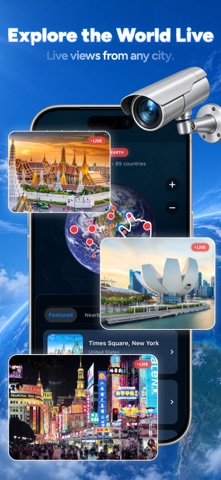
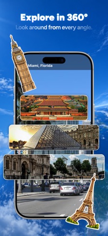
Explore the whole planet from your phone — from orbit down to the sidewalk. Spin a 3D globe, zoom into high-resolution satellite imagery of any address, then drop into street-level panoramas and look around. Along the way, check traffic, track flights overhead, read air quality, and find your bearing with a built-in compass. 3D GLOBE Start from space. Spin the globe, tilt it, and zoom smoothly down to a single street. Terrain and elevation are rendered in 3D, so mountains, coastlines and valleys keep their shape as you descend. HD SATELLITE IMAGERY High-resolution aerial and satellite imagery for locations worldwide. Zoom in on a neighborhood, follow a coastline, or look at terrain that no road map shows. Switch between satellite, terrain and standard map styles. STREET-LEVEL PANORAMAS Drop into a street and look around in 360°. Pan, tilt and move along the road to see what a place actually looks like at eye level — useful before a trip, a move, or a first visit. LIVE PUBLIC WEBCAMS Watch public webcam streams shared by their operators — beaches, city squares, mountain passes and harbors around the world. These are genuine live streams, updated continuously by the people who run them. GPS, COMPASS AND ROUTES See where you are, which way you are facing, and how to get somewhere. A built-in compass shows your heading, and route directions get you from your current location to any place you find on the map. TRAFFIC Color-coded traffic conditions on the map, so you can see where things are moving and where they are not before you leave. FLIGHT TRACKER See aircraft currently in the sky above an area, with route and altitude details for the flights you tap. AIR QUALITY Current air quality readings for locations around the world, so you know what the air is like before you head out. FAST AND LIGHT Maps load quickly and the app stays light on battery, so you can keep exploring without watching your charge drain. HOW THE IMAGERY WORKS Please read this before downloading, so you know exactly what you are getting. Satellite and aerial imagery in this app comes from mapping data providers and is captured periodically — not continuously. Depending on the location, the most recent image may be weeks, months or longer old. This is true of every consumer mapping app: no publicly available service shows a real-time satellite feed of a specific address, and this app does not either. Street-level panoramas are photographs taken at a point in time and are also not live. The one genuinely live part of the app is the public webcam section, where streams are provided in real time by the camera operators themselves. Camera availability depends on those operators and can change without notice. ABOUT THIS APP Live Earth Camera - GPS Map is an independent map and imagery viewer. It is not affiliated with, endorsed by, or sponsored by Google, Apple, or any mapping, satellite or imagery provider. Map, imagery, traffic, flight and air quality data are supplied by third-party providers, and coverage, accuracy and update frequency vary by location and by provider. This app does not provide surveillance of private property, does not show live imagery of any specific address, and cannot be used to observe people or places in real time. Subscription details, pricing and terms are shown in the app before any purchase is confirmed. Payment is charged to your Apple Account at confirmation of purchase. A subscription renews automatically unless it is turned off at least 24 hours before the end of the current period. You can manage or cancel your subscription in your Apple Account settings. Terms of Use: https://www.apple.com/legal/internet-services/itunes/dev/stdeula/
Publisher websiteStore creative
Screenshots



Competitive set
Similar apps
Deterministic links to real stored apps matched by category, publisher, and comparable performance bands.

Waze Navigation & Live Traffic
waze

onX Hunt: GPS Hunting Maps
onXmaps, Inc.

Coyote : radar, GPS & CarPlay
Coyote System

Trucker Path: Truck GPS & Fuel
Trucker Path Inc.

Geovelo - GPS & Stats vélo
La Compagnie des Mobilites

Live Score: Football Result
Infinity Bridge Limited

Mappy - GPS, trafic & prix
MAPPY SA

Speedometer 55 Start. GPS Box.
Stanislav Dvoychenko
How we estimate
Where every number comes from
App details: Apple iTunes Search API, updated Sep 27, 2026, 10:50 PM.
Rankings: collected chart positions from the listed storefront. Missing ranks are not zeros.
Economics: downloads and gross store consumer spend are estimated, not official Apple or publisher figures.
Model: Lineage not exposed by this aggregate.
Confidence: —; intervals widen when evidence or history is limited.
Last updated: Sep 29, 2026, 12:01 AM.
See how AppTrendKit separates observations, estimates, coverage, and confidence.
Open methodology