
Research answer
What AppTrendKit can say about NP Maps - Yellowstone today
NP Maps - Yellowstone has no estimate-backed download or gross-consumer-spend figure that meets the public evidence contract yet.
Observed App Store metadata, chart positions, and history are shown below. Missing, non-finite, undefined-currency, or undefined-metric evidence stays missing rather than becoming zero.
Performance intelligence
Observed trajectory and estimates
Store ranks are observations. Downloads and gross store consumer spend are AppTrendKit estimates and only appear when persisted evidence exists.
Estimated downloads · 30D
ModeledNo persisted estimate
The page does not turn missing evidence into zero.
Estimated App Store gross consumer spend · 30D
ModeledNo persisted estimate
The page does not turn missing evidence into zero.
Estimated downloads · 7D
ModeledNo persisted estimate
The page does not turn missing evidence into zero.
Estimated App Store gross consumer spend · 7D
ModeledNo persisted estimate
The page does not turn missing evidence into zero.
Evidence history
Collected daily performance
No daily metric history has been persisted yet.
Rank history
Observed chart positions
Lower rank is better. Only collected observations are shown.
Coverage note
What the ranks mean
A missing rank is not treated as zero downloads or zero revenue. Apple chart feeds are bounded and may return censored or not-ranked observations outside the visible chart depth.
Read the methodStorefront mix
Top countries by estimated contribution
Country estimates are aggregated only after country-level predictions exist.
Monetization
Observed store economics signals
These are listing and product observations. They are not company revenue, subscriber counts, or advertising revenue.
App details
Store metadata
- Version
- 8.1
- Released
- Jul 31, 2015
- Last updated
- Nov 2, 2022
- Content rating
- 4+
- Default storefront
- FR
Public IAP observations
Validated in-app purchase prices
Only persisted rows with an explicit public publication boundary are shown. Missing price, currency, country, or date values stay unknown.
Listing detail
What the store says
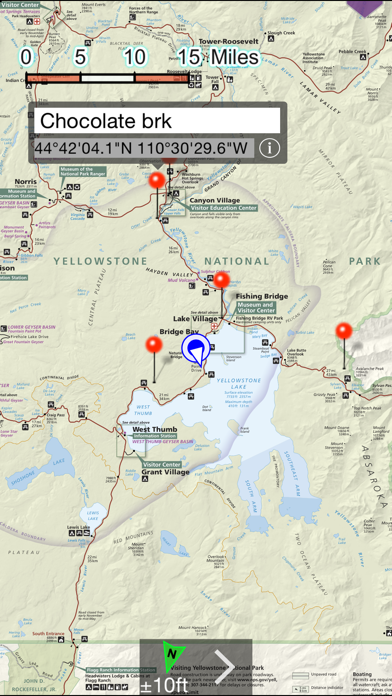
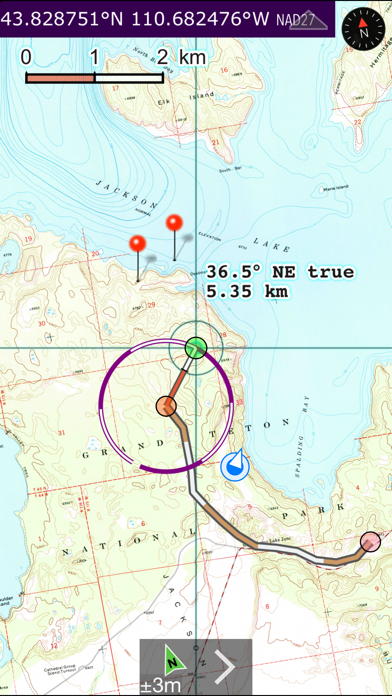
Get maps in high resolution of National Park Service parks and US Geological Survey topography quadrangles of Montana, Idaho and Wyoming on your iPhone and iPad for GPS** and offline use! NP Maps Yellowstone app provides official NPS maps of Yellowstone National Park, Grand Teton National Park and more for you to see your location on them realtime. Plus, being designed for offline use, NP Maps Yellowstone can download official USGS topographic maps for all of the USA and island territories.* This app is priceless for road trips, hikes, camping, exploring, planning and much more! Because many of these wilderness regions have no data service, select and download maps now or while online for your travels so you can enjoy using this app as it was intended: no internet connection. And, this app can detect internet service and automatically install USGS topography or NPS map for your current location if not already done. Logical and intuitive to use. Park and topography maps are geospatially integrated with Apple Maps for a familiar interface and for navigating a visual catalog of maps. A marvelous index into an extensive library covering all of ID, MT, and WY states allows you to select maps for install all with a simple touch along your planned route of travel. Purchase a subscription period for unlimited downloading of more NPS and USGS maps. A subscription stops ads and doesn't auto-renew. The first several map download are complementary. Features: • Preloaded with Yellowstone and Grand Teton NPS maps and two 100k scale USGS topography maps covering Yellowstone. • Access a library of 150 NPS, over 60,000+ USGS & US Forest Service maps • Full rendering high resolution maps • Find geographic features worldwide with a powerful geo-code search • Waypoints with Augmented Reality finder • Route path creation • Track/bread-crumbs GPS path recording** • Shows your current GPS location** • Dual mode ruler with orthographic line and path measuring • Full app usability while maps download in the background • Footprint grid index with quadrangle names for visual map selection • Aligns differing map datums to the WGS84/GPS location • Automatic map download for your current location • Miles, Feet, Kilometers, Meters, Nautical Miles units • MGRS, UTM and geodetic Latitude and Longitude coordinate formats. • Import and export waypoints using GPX format, some support of KLM • Detailed integrated help • Supports rotation and follows heading map orientations • No need for cellular service to use installed maps • A subscription allows for more map downloads, and also stops all advertisements • Email and SMS text waypoints, tracks and routes as GPX files, with subscription purchase * Not preloaded with all maps. WiFi recommended for downloading map quadrangles. First several map downloads are complementary. Downloading queue does cap to around 25 maps. ** Continued use of GPS running in the background can dramatically decrease battery life. Location and AR features won't function for iPod and iPad models without GPS hardware.
Store creative
Screenshots



Competitive set
Similar apps
Deterministic links to real stored apps matched by category, publisher, and comparable performance bands.

NP Maps
Delcartes LLC

Ahamove: Chuyên gia giao hàng
TUC THOI SERVICE CORPORATION

Air Côte d'Ivoire
AIR COTE D'IVOIRE

ANA
All Nippon Airways

BahnBonus
DB Fernverkehr AG

Bestil bus
Via Transportation, Inc.

Bolt: Pede uma viagem 24/7
BOLT TECHNOLOGY OU

BUDAPEST Guía Mapa y Entradas
ZF srl
Methodology and provenance
Read every number with its evidence
Metadata source: Apple iTunes Search API; observed Sep 7, 2026, 8:37 PM.
Rankings: collected chart positions from the listed storefront. Missing ranks are not zeros.
Economics: downloads and gross store consumer spend are estimated, not official Apple or publisher figures.
Model: No persisted model version.
Confidence: —; intervals widen when evidence or history is limited.
Last observation: Sep 7, 2026, 8:37 PM.
See how AppTrendKit separates observations, estimates, coverage, and confidence.
Open methodology