
2GIS: Map, Navigation, Tracker
Research answer
What AppTrendKit can say about 2GIS: Map, Navigation, Tracker today
2GIS: Map, Navigation, Tracker has no estimate-backed download or gross-consumer-spend figure that meets the public evidence contract yet.
Observed App Store metadata, chart positions, and history are shown below. Missing, non-finite, undefined-currency, or undefined-metric evidence stays missing rather than becoming zero.
Performance intelligence
Observed trajectory and estimates
Store ranks are observations. Downloads and gross store consumer spend are AppTrendKit estimates and only appear when persisted evidence exists.
Estimated downloads · 30D
ModeledNo persisted estimate
The page does not turn missing evidence into zero.
Estimated App Store gross consumer spend · 30D
ModeledNo persisted estimate
The page does not turn missing evidence into zero.
Estimated downloads · 7D
ModeledNo persisted estimate
The page does not turn missing evidence into zero.
Estimated App Store gross consumer spend · 7D
ModeledNo persisted estimate
The page does not turn missing evidence into zero.
Evidence history
Collected daily performance
No daily metric history has been persisted yet.
Rank history
Observed chart positions
Lower rank is better. Only collected observations are shown.
Coverage note
What the ranks mean
A missing rank is not treated as zero downloads or zero revenue. Apple chart feeds are bounded and may return censored or not-ranked observations outside the visible chart depth.
Read the methodStorefront mix
Top countries by estimated contribution
Country estimates are aggregated only after country-level predictions exist.
Monetization
Observed store economics signals
These are listing and product observations. They are not company revenue, subscriber counts, or advertising revenue.
App details
Store metadata
- Version
- 7.28
- Released
- Dec 18, 2011
- Last updated
- Sep 2, 2026
- Content rating
- 4+
- Default storefront
- AE
Public IAP observations
Validated in-app purchase prices
Only persisted rows with an explicit public publication boundary are shown. Missing price, currency, country, or date values stay unknown.
Listing detail
What the store says
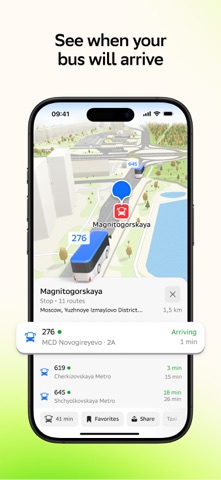
2GIS makes life in the city more comfortable! Map, navigator, public transport, guidebook and directory – all one icon away in your phone. It will show your location, find a required address, help you to plot your route by car, bus, bicycle or by foot. And then you can see your friends right on the map in 2GIS! The app is free and it works both online and offline – just download the required city or even a region and use maps without Internet connection. GPS navigation. Get ready to see precisely depicted roads with tunnels and multi-level junctions in 3D. 2GIS will build an optimal route providing for traffic jam, road accidents and roads under construction. It will show your speed so that you don’t have to glance at speed meter too often. It will give you a warning of speed and other cameras ahead so that you can avoid getting a ticket. It will show you the nearest parking lots. The app combines different technologies to make route following more precise, even on long-distance travels without Internet connection. Turn on 2GIS in Apple CarPlay — it’s free. Maps maxed out. 2GIS is detailed maps of more than 1400 cities: with realistic models of buildings, neighborhoods, roads, bus stops – even trees in a park and entrances to buildings are shown! Floor-by-floor layouts are available for malls, train and bus stations, airports and other complex buildings – you will not get lost! As well as layers with real estate, car sharing and other useful services. Public transport. Build routes by subway, bus, trolley or commuter train. Choose the shortest ones or the most convenient ones, with or without change of transport. Turn on bus tracking on the map in real time. Go by the schedule and see credible estimated time of bus arrival to your bus stop. Navigator for pedestrians, bicycles and scooters. 2GIS can build routes through a city providing for inclinations and elevations, cycle lanes and stairs. It is particularly convenient for scooter riders or people walking with strollers. Friends on the Map. Add your friends and family members as Friends in 2GIS to see each other on the map in the city in real time! No need to ask, “Where are you?”, just check location on the map. It makes meeting planning easier (especially if someone is running late) or allows for spontaneous meetings! Send an emoji to a friend to offer a meeting or start conversation in chat without a need to switch to a messenger. You can also send a link to your location or route to any person, not just friends. And even create temporary groups for travels. Manage who can see your location. It is convenient, private and helps you to always stay in touch. This function may be used as a family location finder: add your child or grandmother and grandfather to Friends and you will not have to worry if they don’t respond in a messenger. You will get an automatic push notification when your relative is at home. Everything about the city. In 2GIS search, you will find contact details of companies and organizations, addresses, business hours, restaurant menus, information on products and services, and even pictures with prices. All information is updated regularly. Reviews. 2GIS not only helps you to find companies, products and services, but also to choose the best of the best! The app stores tens of thousands of reviews, real photos from customers and honest rating of a place. Guidebooks. Discover interesting places just for you in any city! Includes original selections, audio guides and sightseeing attractions in 3D. Navigator for trucks. Cargo navigator gets directions for trucks considering the individual characteristics of vehicles and cargo. The Apple Watch companion app conveys a map and a route created using your phone on your watch screen, and also shows your current location. Vibration will alert you when you need to turn. The Friends on the map widget on the main screen will keep you informed of your loved ones' whereabouts. Support: dev@2gis.com
Publisher websiteStore creative
Screenshots




Competitive set
Similar apps
Deterministic links to real stored apps matched by category, publisher, and comparable performance bands.

Anchor Watch Alarm ZENKOU PRO
UNITIO PLUS SL

Aral pulse
bp Advanced Mobility Limited

AT Mobile
Auckland Transport

Autel Charge
Autel Digital Power Co., Ltd.

Auto Chilango
Auto Apps de Mexico S de RL de CV

Avenza Maps: Offline Mapping
Avenza Systems Inc.

bePartner
be Group JSC

bergfex: Hiking & Tracking
bergfex GmbH
Methodology and provenance
Read every number with its evidence
Metadata source: Apple iTunes Search API; observed Sep 7, 2026, 8:39 PM.
Rankings: collected chart positions from the listed storefront. Missing ranks are not zeros.
Economics: downloads and gross store consumer spend are estimated, not official Apple or publisher figures.
Model: No persisted model version.
Confidence: —; intervals widen when evidence or history is limited.
Last observation: Sep 7, 2026, 8:39 PM.
See how AppTrendKit separates observations, estimates, coverage, and confidence.
Open methodology